What we do is costly! Your support will help us dig more stories.
Yes, I'm Interested!Ignorance isn't always bliss | Don't stay foolish.
Keep informed | Read our news and analysis.
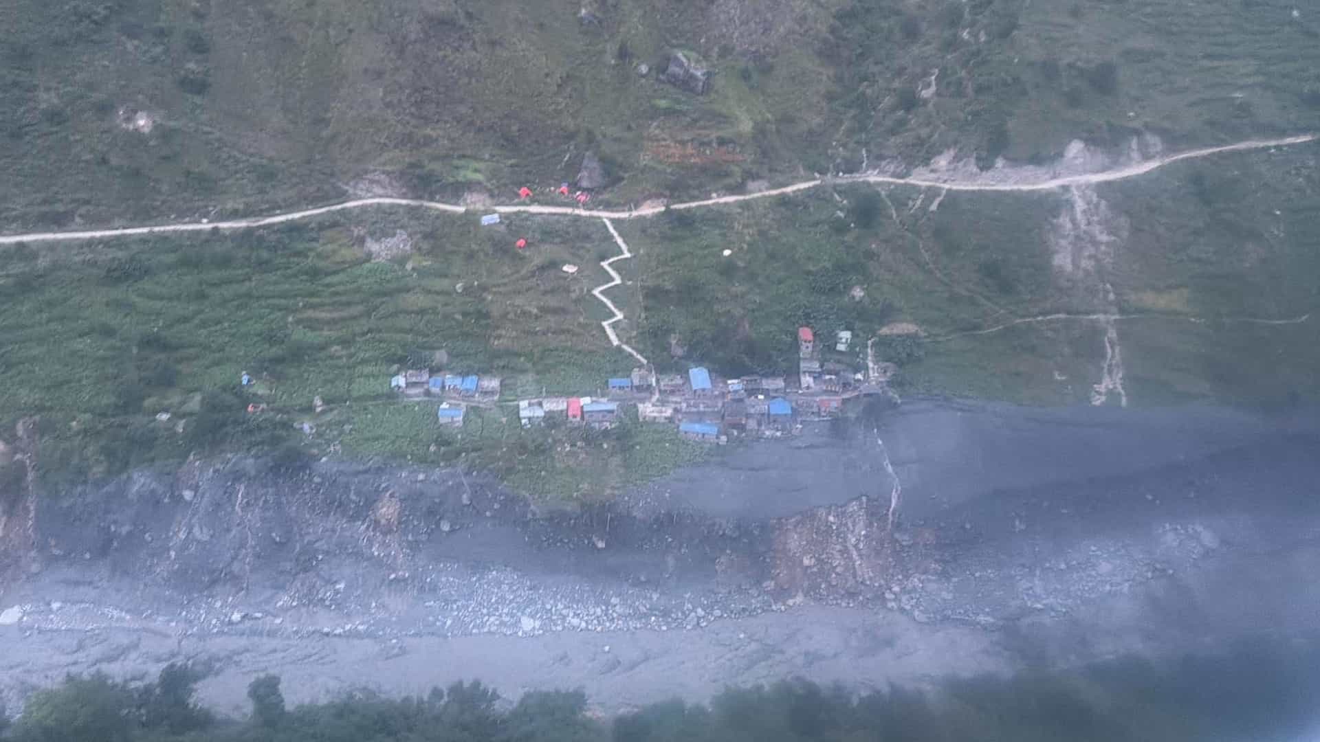
An avalanche in the high mountains of northern Gorkha, followed by a massive slope failure and the accumulation of debris in river channels, triggered the destructive flash flood along the Budhi Gandaki River on October 11, according to preliminary technical findings.
The findings suggest that the disaster was not caused by a single landslide blocking the river. Instead, a chain of events involving snow, water, rock and sediment appears to have amplified the volume and destructive force of the flow as it moved towards downstream settlements.
The sequence, documented in a technical assessment by NDRRMA, began in the headwaters of the Ungilung stream in Chumnubri Rural Municipality-6. The assessment identified an avalanche at an elevation of approximately 5,500 metres between Chamar Himal and Syerangi Himal, at around 4:20 AM on October 11.
The resulting flow carried snow, water and debris down the mountain, depositing material along drainage channels and obstructing streams before the accumulated water and debris surged downstream. The findings provide a more detailed explanation of the disaster than initial accounts that attributed the flooding primarily to a landslide-induced river blockage.
The Centre of Hydrology and Water Resources Research, under the government’s Water and Energy Commission Secretariat, issued a situation report on the unusual flooding on October 12. The International Centre for Integrated Mountain Development (ICIMOD) subsequently highlighted evidence of a rock avalanche and glacier collapse in the Budhigandaki basin, while noting that further investigation was needed to establish the event sequence and its implications for disaster risk reduction.
The preliminary findings underline how multiple mountain hazards can interact to produce a destructive flood, complicating efforts to anticipate such events using conventional river monitoring alone.
How the flood developed
According to the technical assessment, the initial collapse sent a large volume of snow, water and debris down the Ungilung stream. The flow affected areas along both sides of the channel, with the report estimating that its impact extended as high as 300 metres above the stream in places.
At an elevation of around 2,000 metres, debris accumulated at the narrow confluence of the Ungilung and Syar streams, obstructing the Syar stream. The obstruction subsequently gave way. A similar process may have occurred where the Syar stream meets the Budhigandaki River, although the assessment presented this as a possible explanation rather than a conclusively established sequence.
The volume and composition of the debris were important factors in the flood's destructive force. The assessment attributed a substantial part of the rising flood level to the mass of sediment carried by the Ungilung stream, rather than simply to water accumulating behind a temporary natural dam.
The Syar stream reportedly stopped flowing about an hour before the largest flood surge. Field observations indicated that water had accumulated along approximately 1.5 kilometres of the upper stream. Smaller surges followed the main flood, suggesting that the release of water and debris was not a single, instantaneous event.
The flood reached Salleri at around 4:30 AM, according to the technical findings. Its largest surge arrived at a hydropower project construction camp in Salleri at approximately 6:30 AM, where the flood level was estimated to have reached 20 to 25 metres.
The assessment attributed significant damage in downstream areas, particularly Jagat, to the force of the surge, including damage to buildings and bridges over the Soti Khola and Budhigandaki River.
The flow was described as a viscous mud flow containing substantial amounts of soil, sand and rock. Material from the source area, including sedimentary rock and soil-rich debris, contributed to the thick, sediment-laden flow. Such flows can carry large quantities of sediment and inflict extensive damage on structures along river corridors.
The findings remain preliminary. Further field investigations and analysis are needed to establish the precise sequence of failures, the volume of material involved and the implications for other vulnerable mountain catchments.
The flood affected Chumnubri and Dharche rural municipalities in Gorkha, destroying houses, bridges and other infrastructure and disrupting access to settlements in the Manaslu and Tsum Valley regions. By October 15, authorities had evacuated 1,044 people by helicopter, including 70 foreign nationals. More than 1,200 farm animals and poultry were also reported lost. For households in remote mountain communities, livestock can represent a significant share of household assets and income.
Early-warning timelines raise questions
The sequence of warnings and the timing of the flood also warrant scrutiny.
Residents along the Budhigandaki had begun reporting flooding before 5 AM on October 11. Residents’ accounts in media reports suggest a warning was conveyed by telephone at 4:45 AM, followed by social media posts since 4:59 AM, urging people downstream to remain alert.
However, the NDRRMA’s initial response report recorded a major landslide at 5:30 AM and said water began flowing through the blockage at 6:15 AM, triggering a major flood.
The discrepancy between the locally reported warning and the official timeline raises questions about when the obstruction was first detected, how information moved between communities and authorities, and how the event was subsequently documented. It does not, by itself, establish that officials ignored an earlier warning.
The same initial report recorded water levels at the Budhigandaki-Arughat gauging station rising from 2.28 metres to 3.66 metres at 6:30 AM. With the warning threshold set at 4.50 metres, authorities sent SMS alerts to residents along riverbanks. At 7:50 AM, the level reached 5.01 metres, exceeding the danger threshold of five metres. It climbed to 6.22 metres at 8:30 AM and 8.43 metres at 8:40 AM.
The authority said approximately 200,000 warning messages had been sent.
These figures describe the monitoring and response recorded in the initial report. They do not establish exactly when each affected household received an alert or whether the messages reached communities closest to the source before the flood arrived.
That distinction is particularly important in remote mountain valleys, where the interval between an upstream collapse and a destructive downstream surge may be too short for conventional river-gauge thresholds and SMS warnings to provide adequate protection.
A more complete assessment should examine not only whether warnings were issued, but also when the first signs of the hazard emerged, who received information, how quickly it was relayed and how much time residents had to evacuate.
A wider Himalayan risk
The Budhigandaki disaster has renewed concerns about cascading hazards in the Himalayas. It occurred less than two months after the catastrophic flooding in the Rasuwa-Bhotekoshi corridor in August. The two events should not be assumed to have identical causes, but both underline the vulnerability of mountain settlements and infrastructure to sudden, destructive flows.
ICIMOD’s October 11 preliminary assessment said a landslide-generated temporary river blockage near Chumchet may have failed, triggering the Budhi Gandaki flash flood. In its October 13 update, the regional research centre highlighted evidence of a rock avalanche and glacier collapse in the basin and the need to investigate the event further.
The findings point to a limitation of warning systems designed primarily around rainfall and river-level monitoring: they may not detect a sudden collapse at high altitude early enough to protect communities downstream.
Monitoring unstable slopes, glaciers and high-altitude drainage channels could complement existing hydrological systems. Satellite imagery, aerial surveys and local observation networks may help identify emerging hazards, but detection alone is insufficient. Information must reach authorities and communities quickly enough to prompt action.
For remote settlements, effective warning systems also require communication arrangements that work when mobile networks, roads and electricity supplies are disrupted. Local preparedness, evacuation routes and clearly assigned responsibilities could make a difference when the time available to respond is limited.
The immediate priorities in Gorkha remain reaching isolated communities, providing relief, restoring essential services and determining the full extent of the damage.
Read More Stories

Nepal needs to repeat to brand itself
Last year Nepal's goods exports jumped 81.8% to NRs 277.03 billion. That is...

Banking stocks gain momentum as dividend season begins
Dividend announcements by banks and financial institutions (BFIs) for fiscal year 2025/26 have...

Nepal’s challenge of building strong democratic institutions
Over the past few decades, institutional dysfunction and massive dissatisfaction with political establishments...