What we do is costly! Your support will help us dig more stories.
Yes, I'm Interested!Ignorance isn't always bliss | Don't stay foolish.
Keep informed | Read our news and analysis.
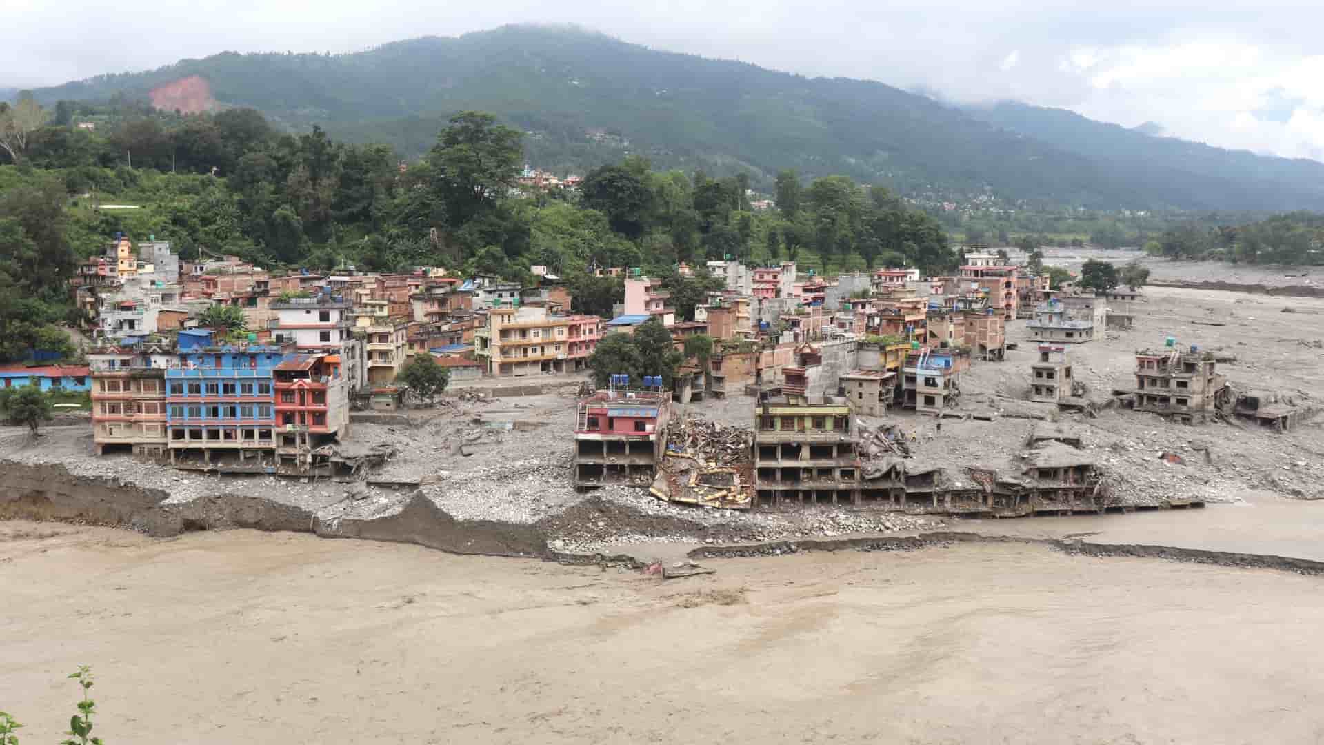
On the morning of 26 August, a glacier-related ice and rock avalanche near the Nepal-China border set off a chain reaction: landslide, temporary river blockage, then a catastrophic flash flood, tearing through Rasuwa, Nuwakot, and Dhading districts along the Trishuli River. Nearly a thousand are confirmed dead, over 4,000 more remain missing. Roads, bridges, hydropower infrastructure, and the entire settlements have been destroyed. Around 10 thousand households need immediate relief.
The first responsibility during such a crisis is to rescue survivors, support affected families, and restore essential services. But Nepal must also use this tragedy to ask a more fundamental question: are we preparing for the disasters we have already experienced, or for the emerging risks?
For decades, disaster management has largely followed a familiar cycle: hazard, emergency response, rebuild, strengthen preparedness, repeat. That cycle remains necessary, but it is no longer sufficient. Not very long ago, the country experienced a devastating earthquake in 2015. Since then, in just a matter of a decade, flash floods, landslides, droughts and other climate extremes have become a recurring feature of Nepal’s risk landscape, arriving more frequently, more intensely, and with less warning.
A 2023 World Bank report on climate risk in Nepal identifies river flooding, heat exposure, drought and landslides as the country’s key climate hazards, noting that river floods and landslides are the most frequent hazards over the past four decades, while drought and heat exposure are increasing.
In a warming Himalaya, hazards increasingly interact: a glacier can destabilise a slope; a landslide can block a river; accumulated water can suddenly be released; debris can transform a river into a destructive flow. Scientists call these cascading or compound hazards, and each event can change the conditions for the next.
Nepal needs to move from a predominantly reactive disaster-management model to an anticipatory resilience model.
Anticipation begins with recognising that uncertainty itself is a risk to be managed. We cannot predict exactly when a glacier will collapse, when a landslide will occur, or when a river blockage will fail. But we can identify vulnerable valleys, monitor changing slopes and glacial lakes, map cascading pathways, set thresholds for action, and prepare communities before a crisis unfolds. That authorities are now monitoring newly formed upstream lakes in the aftermath of this disaster is exactly the point: risk assessment has to continue even after the immediate event, not stop once the cameras leave.
To tackle this complex challenge, sophisticated technologies are important, but technology alone is not sufficient. We must go beyond technology. An early-warning system is only as good as the early action it triggers. A satellite can detect a changing lake, a sensor can detect rising water, a model may predict a flood, but someone still has to receive that information, understand it, trust it and have the authority and resources to act on it. That means evacuation routes, safe shelters, communication systems, drills, local emergency funds, and clearly assigned responsibilities. It means designing warning systems with communities, not simply delivering to them.
It also means asking who receives the warning and through which channels. Evidence shows that 71% of men in one study received early warning information through formal sources such as government agencies or NGOs, while 51% of women received warnings through informal sources such as family or community networks. An early warning system that does not account for these differences may technically cover a population while still leaving some people less able to act.
This is where Nepal's rich tradition of community-based natural resource management has something concrete to offer. Community forest user groups, farmer-managed irrigation systems and community seed banks are not folklore:– they are functioning institutions of collective risk management that have sustained rural livelihoods through droughts, floods, and conflict for decades.
The scale of Nepal’s community forestry experience is itself significant: around 35% of the population belongs to community forest user groups, which collectively manage about 2.4 million hectares of land. These institutions demonstrate that Nepal already has a substantial social infrastructure for collective resource management. The challenge is to connect such institutions more deliberately with disaster-risk information, early action and local adaptation planning.
Local people possess detailed knowledge of rivers, slopes, weather patterns, springs, forests, and changing landscapes. That knowledge should not be romanticised, nor be treated as a substitute for science. But when paired with scientific monitoring, it becomes locally grounded risk intelligence that satellites alone cannot detect.
It also matters who bears the greatest costs when preparedness fails. Women, children, older people, poorer households, people living with disabilities, informal workers and farmers, livestock, and grassroot tourism workers typically have fewer options to evacuate, relocate or recover. Climate resilience that ignores this will simply reproduce existing inequality at greater scale. Resilience therefore must be socially inclusive, not merely technologically sophisticated.
Nepal also needs to rethink what “rebuild” means. Reconstructing a road, bridge, or hydropower facility at the same areas may restore infrastructure without reducing the risks that destroyed it in the first place. Before the next reconstruction budget is committed, planners should be able to answer a question: given how the hazards are changing, does rebuilding here, in this form, make communities safer or simply reset the clock until the next event?
None of this can be achieved by a single ministry or a single sector. It requires coordination across climate science, disaster management, local government, infrastructure planning, agriculture, water resources, tourism, and social protection. It also requires transboundary cooperation, because Himalayan hazards do not stop at national borders. The glaciers, rivers, and mountain systems linking China, Nepal, and India and the countries further downstream form one interconnected risk landscape.
The lesson from this national tragedy is not simply that Nepal needs a better emergency response. It needs a new model of anticipatory, community-centred climate resilience, one that connects science with local knowledge, early warning with early action, infrastructure decisions with future risk, and national planning with the realities of communities living on the frontlines of a changing climate.
We cannot prevent every Himalayan hazard. But we can ensure that fewer hazards become disasters. More than that, how quickly we recover from what has already happened should be the measure of our progress.
Read More Stories
Why IPPAN opposes SEBON’s proposed IPO rules
The Independent Power Producers Association, Nepal (IPPAN) has urged the Securities Board of...

Market climbs by 4.12 points, turnover amounts NRs 4.68 billion
The Nepal Stock Exchange (NEPSE) climbed by 4.12 points (0.16%) to close at...

Junior PHP Developer (WordPress & Divi) – Internship / Entry Level
A small, new digital agency looking for a motivated junior developer to join...