What we do is costly! Your support will help us dig more stories.
Yes, I'm Interested!Ignorance isn't always bliss | Don't stay foolish.
Keep informed | Read our news and analysis.
INFRASTRUCTURE | CONNECTIVITY | BORDER TRADE | KARNALI PROVINCE | TRANSNATIONAL CORRIDOR
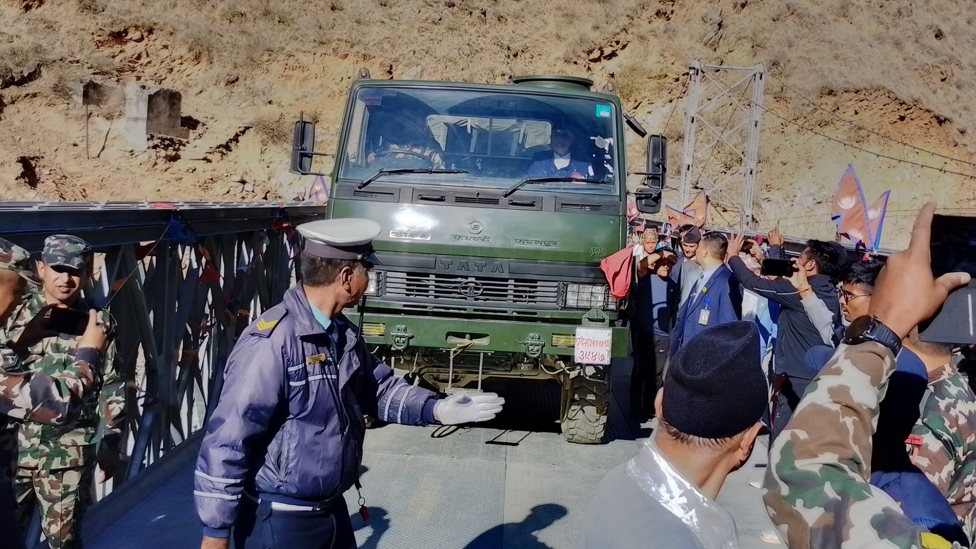
After more than two decades of slow and arduous progress, Humla is now formally connected to Nepal’s national road network, following the installation of a Bailey bridge over the Chuwakhola River in Kharpunath Rural Municipality–5. The bridge connects its district headquarters, Simkot, with the Karnali corridor.
The Nepal Army had begun the installation work on March 23 and completed the bridge on June 24, which was officially inaugurated by Prime Minister KP Sharma Oli on July 6.
Speaking at the ceremony, Oli said, “The Karnali Corridor is not only for the people of Karnali and Humla; it is also a trade route with our two neighbouring countries. Therefore, it should be immediately upgraded to two lanes and blacktopped.”
However, a permanent bridge is yet to be constructed.
|
What is a Bailey bridge? A Bailey bridge is a portable, pre-fabricated truss bridge typically made of steel and can be assembled quickly without the use of heavy equipment. It was originally developed during World War II by the British for military use, allowing troops to cross rivers and ravines in combat zones. |
Bailey bridges are commonly used in remote and mountainous regions like Karnali and Humla, where building traditional bridges is extremely difficult due to the rugged terrain.
Since permanent bridges are often planned but not yet constructed, these steel, pre-fabricated structures serve as temporary yet reliable solutions. Although Bailey bridges are not permanent, they play a vital role in ensuring connectivity until more durable infrastructure is built.
A long-delayed link
Karnali Corridor is a National Pride Project, running over 400 kilometres from Jamunaha in Banke district to Hilsa in Humla. The current section of the corridor links Humla to the country’s road network stretching from Khulalu in Kalikot, passing through the district headquarters Simkot in Humla, and reaching up to Hilsa.
Construction of the corridor began roughly 26 years ago in the late 1990s, but progress has been hampered by difficult terrain, administrative delays, and inconsistent state attention. The corridor’s first 107 kilometres section, from Hilsa near the Chinese border to Simkot, was completed in 2019. Similarly, in the month of Falgun last year, a multi-year contract worth over four billion rupees was initiated to blacktop a 50-kilometre stretch of the Khulalu–Hilsa road.
Although a motorable track had reached parts of Humla in recent years, Simkot remained disconnected from the national road grid until the completion of the Chuwakhola bridge last month.
With this connection, vehicles can now pass from Surkhet to Simkot, and onward to Hilsa, Nepal’s border point with China’s Tibet Autonomous Region. The road opens up a 500+ kilometre north-south transnational trade link, envisioned to connect the Indian border at Rupaidiha with the Chinese border at Hilsa.
Writing at X before the inauguration of the bridge, PM Oli wrote that the road links the country’s southern neighbour India with northern neighbour China via road for the first time. “This highway begins at Jamunaha, a border region in Banke, and stretches all the way to Hilsa, a border region in Humla that connects to China. Spanning 410 kms, the road integrates Karnali into a transnational north–south road network and is set to aid our foreign trade,” he further added.
Trade and strategic potential
During the inauguration, PM Oli also pledged to build a quarantine facility at Hilsa to enable trade with China. “There is immense potential for cross-border commerce here,” he said, adding that immediate quarantine infrastructure is essential for that vision to materialise.
Currently, the Hilsa–Purang (China) border point remains underutilised due to the lack of customs and immigration infrastructure on Nepal’s side. China, meanwhile, has already built roads and expanded trade infrastructure up to its side of the border.
With the corridor now physically connected, there is a growing anticipation that Karnali could become the country’s third strategic overland commerce route after Rasuwagadhi and Tatopani if government policies keep pace with infrastructure.
A milestone, not a finish line
While the connection of Simkot is historic, the corridor remains incomplete in terms of quality and functionality. Much of the route is still an unpaved track prone to landslides and seasonal disruption. Locals continue to demand investments in road surfacing, bridges, and supporting infrastructure such as electricity, communication, and public services.
Still, for Humla—a district where goods were once flown in by air cargo and mule trails served as highways—this is a watershed moment. After 26 years, the road has finally arrived.
(With inputs from Rastriya Samachar Samiti)
Read More Stories

Kathmandu this week: Rock performances and poetry sessions
After seven years of construction, Nepal inaugurated its first modern road tunnel on...

NEPSE drops sharply, loses 33 points
The stock market declined sharply on Monday, with the NEPSE index falling 33.28...

NEPSE gains 7.90 points as turnover rises to NRs 6.26 billion
The Nepal Stock Exchange (NEPSE) continued its positive momentum after rising 14.17 points...