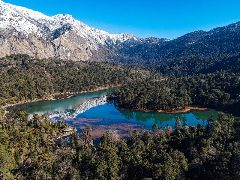
Far West | Saipal base camp | Ramaroshan | Api base camp | Khaptad National Park
“If you don’t go to very difficult roads, you will only reach places where everyone reaches.”
- Mehmet Murat Ildan
Names of places in the far western region come to people sporadically, either when political issues arise or are conjugated with unfortunate natural disasters. However, other factors reciprocating the specific geographical area are often overlooked.
The Far Western region or Sudurpashim Province is abundant in natural beauty. The snowscapes, streams, meadows, forests, and wildlife are breathtaking but unexplored. Except for people residing here, the region remains untouched, so far, unnoticed in every way.
Here are some places that rest in Sudurpaschim that need to be addressed and acknowledged.
1. Saipal base camp

Located in the northwest of the Bajhang district, home to former Bajhangi royals, Mt. Saipal stands with an elevation of 7,031 metres. It is a part of the Gurans Himal range (a sub-range of the Himalayas) with mountains like Api Mountain (7,132 metres), Rokapi (6,468 metres), Jethi Bahurani (6,850 metres), Nampa (6,755 metres), and Bobaye (6,080 metres).
Bajhang is the largest district in the province with an area of 3,422 square kilometres.
The trek to Saipal base camp is approximately eight days long starting from Panalta of Talkot Rural Municipality, where the pitch road comes to an end. The route along Dhalaun, Jima, and Doodale finally reaches Aaulagaad.
It then takes a three-day trek to reach Mt. Saipal from Aaulagaad. The journey to Saipal base camp allows us to come across several fascinating and alluring scenarios.
At the periphery of Saipal base camp, about 3,800 metres above sea level, a place called Raidhungi has an eye-pleasing beauty with meadows, lakes, mountains, glaciers, waterfalls, and cliffs.
Along with the locals, people from outside the district go there in search of medicinal herbs, such as Yarshagumba, in the starting Summer — stay there for two to three months till the Monsoon ends as they bag enough herbs. The stories, conversations, and experiences you will hear from the local people are exhilarating.
The road that leads to Saipal base camp is rather difficult. During the monsoon, the roads become muddy and slippery. The fluctuation in weather is quite normal in the base camp area. But the warm hospitality and the natural beauty surrounding the base camp are worth the struggle.
Mt. Saipal is the second-highest peak in the western region after Mt. Api. The first attempt to climb Mt. Saipal took place in 1953 by Dr. Herbert Tichy, an Austrian. The first successful ascent was made a decade later by a Japanese expedition. On October 21, 1963, Katsukoshi Hirabayanshi and Pasang Phutar reached the south side of the summit.
2. Ramaroshan

Ramaroshan, situated in the Achham district is one of the most beautiful yet underrated places of Sudurpaschim province. The refined beauty of Ramaroshan is elevated by 12 freshwater lakes and 18 patches of meadows, locally named Barha-banda and Atharah- khanda simultaneously. The lakes and meadows are surrounded by thick forests.
Situated at an altitude of 2,500 metres, it consists of Batulla taal, Jingle taal, Mathillo Dhaune taal, Roshan Maidaan, and Kinimini taal along with alluring peaks such as Dodari (2,800 metres), and Chankha daanda (3,820 metres).
Chankha daanda is the highest peak of Ramaroshan allowing us to see the Gurans mountain range of Sudurpaschim, the Kumaun mountain range of Uttarakhand (India), and the mountains of Humla and Jumla residing in Karnali province.
From Mangalsen, it takes a four-hour drive to reach Ramaroshan.
Compared to other places, it is easier to reach there as public transportation is accessible. The roads are more straightforward and the scenarios are stunning. Not only the natural beauty but also the lifestyle, culture, and beautiful villages are equally alluring.
3. Api base camp

Linked with the borders of India and Tibet, Api is the highest peak of Sudurpaschim province with an elevation of 7,132 metres and a prominence of 2,040 metres. Api base camp lies in the Api Nampa conservation area, in Darchula district. The Api mountain is accompanied by other majestic mountains such as Jethi-Bahurani (6,850 metres), Nampa (6,757 metres), Babai, and many more.
Api base camp is one of the least trekked areas in Nepal because the roads are stiff and dangerous. The trek to Api base camp is 5 days long from Gokuleshwor of Darchula.
One can reach Gokuleshwor by bus from Dhangadhi. From there, it takes a 4-hour drive to reach Makarigaad, where the motorable roads come to an end.
The trek begins from Makarigaad and leads to the rural villages of Ghusa, Siti, and Shimar followed by Dhauli Odhar from where it takes approximately 2- 2.5 hours to walk to reach Api base camp.
At the junction of the Chamelia and Dumola rivers, Dumoula temple resides. Locals believe that you shouldn’t vow to visit the temple unless you can keep it. If you fail to offer what you pledged to the Dumola god, it is believed that you will lose everything you own.
On the way, Mt. Kangiyo Kor and other unidentified peaks are visible.
Situated 4,100 metres above sea level, Kali Dhunga Lake subsites inside the periphery of Api base camp. Yarshagumba harvesting in the area starts as soon as the lakes defrost.
Even if the path is difficult and dangerous, the sight of Api Mountain tucks away everything and fills oneself with amusement and thrill. The forests, wildflowers, the sight of yaks (jupo), interaction with local inhabitants, and their warm and welcoming gestures are enormous.
Himalayan Tahr (jharal), different types of Rhododendrons, and herds of mules and sheep are enough to bewitch the visitors.
4. Khaptad National Park

Whilst discussing the natural beauty of Sudurpaschim, it is incomplete without mentioning Khaptad National Park. A large number of people must have heard the name, perhaps only a few have experienced its ethereal and serene beauty.
Khaptad exists at the intersection of four districts: Bajhang, Bajura, Achham, and Doti with an area of 225 square kilometres, including 216 square kilometres of designated buffer zone.
It is the only national park of Nepal situated in the mid-hills ranging between 1,400 metres and 3,300 metres. The premise of the national park consists of 22 pastures, 53 lakes, and 12 caves.
Khaptad is considered to be a great pilgrimage for the Hindus. According to the Department of National Parks and Wildlife Conservation (DoNPWC), a great spiritual saint, the late Khaptad Swami, originally known as Swami Sachchidananda moved to the area in the 1940s to meditate and worship and spent 50 years in the valley as a hermit. He, who was also known as Khaptad Baba, was a philosopher, physician, astrologer, and scientist. The place he resided during his stay is known as Khaptad Ashrama. The park was reportedly established on the advice of him in 1984.
Akashganga flows from the east, Nilganga from the north and Swarnaganga from the Sahashralinga. Collectively they are called Triveni, the confluence of three rivers. It lies near the park headquarters. On the northeastern part of the park, Khaptad Daha (lake) is present. Ganesh temple, Nagdhunga, and Kedardhunga are some of the other religious sites that exist inside Khaptad National Park.
These places are particularly for meditation and calmness. Consumption of alcohol, tobacco, and sacrificing animals is completely forbidden on the site.
Besides the religious point of view, Khaptad National Park is an equally unique and vital ecosystem. Flora and fauna of Khaptad is impeccably rich. The ecosystem of the national park can be branched into two types of vegetation i.e. subtropical forests in lower altitudes and temperate forests in Khaptad plateau.

Significant species of vegetation found on the site are fir, oak, birch, chirpine, spruce, maple, alder, and rhododendron. About 135 species of flowers bloom beautifully in summer and late spring over the landscape of the Khaptad plateau. The beauty possessed by Khaptad is absolutely mesmerising and is a feast to the eyes.
Alongside, Khaptad National Park is home to 226 bird species, among which 175 are breeding bird species. This makes Khaptad felicitous for birdwatching. Impeyan pheasant (Danphe), several types of partridges, flycatchers, bulbuls, cuckoos, and eagles are some common birds found in the national park. It is a habitat for an expansive range of butterflies, moths, and insects too.
About 224 varieties of medicinal herbs are found in the national park, which is 13.8% of what is found all over Nepal.
Khaptad National Park resides at 446 km air distance from Kathmandu. There are several routes leading to the entrance of Khaptad National Park. A flight to Dipayal from Kathmandu where local buses to Silgadhi are available. From there, it takes a 6-hour hike to reach the park entrance.
Likewise, a flight to Achham or Bajhang is followed by a two-day walk. A flight to Bajura is accompanied by a four-day walk.
There is no accommodation facility available inside the premises, according to the DoNPWC. If one is thinking of visiting and staying in the National Park, they should carry the tent and other things used for camping as there is no homestay or hotel that can be used.
Spring (March-May) and Autumn (October-November) are the best time to visit the park as the climate is favourable. The temperature ranges from 10 to 20°C, which makes it easier to hike. During the full moon of July-August, Hindu pilgrims visit Khaptad Baba Ashram to worship Lord Shiva.
Even though these areas are distinct and packed with profound natural beauty, they aren’t visited as much as they should be — lack of simple amenities such as safe roads, stable phone networks and internet, and proper hospitality facilities being major deterrents.
The lack of investment in tourism, and insufficient promotion of the destination along with their local art and culture are also what make these regions ‘hidden gems’.
Read More Stories
Kathmandu’s decay: From glorious past to ominous future
Kathmandu: The legend and the legacy Legend about Kathmandus evolution holds that the...
Kathmandu - A crumbling valley!
Valleys and cities should be young, vibrant, inspiring and full of hopes with...

We are currently hiring for multiple positions within our organization. If you are...

Subscribe to Us for Insight on Biz. Fin. Econ. Tech & Environment. Nepal & South Asia. In-depth Analysis. News. Investigation. Research. Expert Opinion. Anatomy of Complex Issues.